Tag Archives: Vancouver Island

Cape Scott, 1 Aug 2015

Andrew W. at Cape Scott:
“Six hikers planned to hike in Cape Scott Provincial Park on the August long weekend. Planning was a breeze, meals were arranged, group gear sorted and carpool and tent space for all confirmed.

The Cape Scott Trail itself was very dry (a far contrast from the mud that Cape Scott is famous for) and the beaches all so sandy and beautiful. The weather was incredible with only a little bit of rain in the morning while we were safe in our tents. Surprisingly the trail was not very busy at all nor were the campgrounds. It was cooler temperature wise than in Vancouver but still warm so everyone went for a swim a couple afternoons to cool off and relax the muscles. Sleeping with the sound of waves crashing on the beach made for restful nights.

Nels Bight was our campsite of choice for two nights with a day hike to the lighthouse part of our journey. We camped at San Josef Bay for our final night as to provide a change of scenery and a shorter hike out to the car before the long drive home.

Plenty of food was shared among all, including a buffet of freeze dried meals providing ample opportunity to sample!

Lots of wildlife was spotted, including but not limited to: black bears, humpback whales, eagles, squirrels, I’m likely forgetting one or two sightings, there were a lot!

A wonderful way to spend a long weekend with great company!”

Sunset

Galloping Goose, 31 Aug 2013

Keith cycling the Galloping Goose trail:
“I had Markus and Amy sign up for the jaunt and the weather was perfect. Recently I have done a few things I have not done before and many have been bike related: Pemberton Slow Food Cycle Tour, Whistler Gran Fondo, and cycling the Oregon Coast as well. I have made crabapple hot pepper jelly as well for the first time – great with camembert on crackers! Galloping Goose was one I have wanted to do for a while and it looked like a good time to do it. The trail is about 180 km to Sooke and back to the ferry. It is an old rail bed so I think the grade is no more than 2 or 3 % – even though when everything is flat you notice the “hills”.

The group met up and we were off! The ride into Victoria was basic – the trail is mostly crushed gravel and mixed with pavement. We stopped to say hi to the pigs and they were not so interested. I bowled an orange towards one of them but no movement. The blackberries were big, juicy, ripe, tasty, plentiful and easy to pick. The blackberries seem to get another month in Victoria and are usually better. They were good. BC Ferries had a blueberry promo with White Spot on the ferry – I considered taking off the blueberries in the café to make their offering more tasty and more local; I decided this would be frowned upon.

We had a stop at Thrifty’s for lunch and got a few supplies. Amy had some issues with her bike Clunky Sue with the chain jamming. We continued on. We found a bike shop that did a bit of work and got it hopefully running along well. There are not many bike shops along the route and if you see one and THINK you need something looked at – stop in! The owner of the shop was very thankful for blackberry thorns – he seems to do good business with punctures due to them.

After we were fixed up and a couple of near misses between bikes, the trail was meandering and nice. As we neared Sooke you cross the Sooke Road and Sooke is still about 30 minutes into Sooke proper. If you want dinner out there is a pub called the Stickleback just 2 minutes west down the road before the Shell station. The beer selection is great and the food tasty and reasonable – get the tsunami fries!

The trail is very pleasant and has different smells along the way – from moth balls, to watermelon, to sweet blackberries that are past their prime. We rolled into the Sooke Potholes campground around 7 pm or so and set up for the night after biking some of the bigger trestles – didn’t realize how high up they are. There is a spot for bikers to camp with a big fire ring. I had a dream about a wolverine-like man attacking us, but nothing actually happened. This time 🙂

We had a quick but really nice swim at the potholes in the morning and biked on back towards the ferry. We (I) picked some more blackberries – they were just that good. We saw one rabbit, some pigs, horses and that’s about it.

I met a guy on the ferry who I called White Bread Will as that was what he ordered for food after cutting Markus off in the line up, he was drunk and was biking to Winnipeg on a rough looking machine. I urged him to get some air in his tires as they were super low.

The trail is easy to follow, flat, and a great trip for the fall. Overall a great trip that can be done as a day trip or comfortable 2 or 3 day trip.

Overall a fun trip and great weather!!”

Juan de Fuca Trail 29/06/11

Steve C. on the Juan de Fuca trail:
“The Juan de Fuca trail stretches 47 km from Jordan River to Port Renfrew on the rugged west coast of Vancouver Island. Shorter and easier than the famous West Coast Trail which neighbours to the northwest, the Juan de Fuca trail still provides a challenging backpacking route, and is a great introduction to the rigors of coastal hiking.

Our JDF team of semi tent-less strangers (four with tents and two with a “tarp”) (Bala, Susanne, Sherron, Pieter, Angela and Steve) assembled at the China Beach campground on Wednesday evening, after a semi-frantic dash to catch the 7 pm ferry and a precarious convoy across Greater Victoria to the campground. That evening had us all falling asleep to the gentle sound of rain and much “tarp talk” emanating from the two brave tarpers. We all learned of the origins of tarp camping and how it was invented by a rocket scientist who no longer wanted to be a rocket scientist but took on a new passion for the outdoors. Out of this was invented the tarp as a way to minimise weight. Rain that night seemed to confirm the discouraging weather forecast, but after it cleared the next morning we wouldn’t see the wet stuff again until our last night of camping. Before we could start the trail we needed to place our two vehicles at either end of the trail. Two hours of car faffing later, our international team (Canadian, Swiss, German, Indian, Dutch and English) was ready to hit the trail.

The first day’s hike to Bear Beach is rated as “Moderate”, and this turned out to be a fair description, with easy terrain but quite a few ups and downs. Much of the trail was in the forest with the exception of a short section around Mystic Beach. The campsite at Bear Beach was quite busy, but we were able to find a quiet spot to ourselves at the far western end of the beach near to the picturesque “Mushroom Rock”. After supper we were all treated to an “Indian style” campfire, differentiated from its Canadian counterpart by the use of accelerant, an interesting grid structure and a higher success rate. The “Canadian fire” the following night (courtesy of Sherron) was however more aesthetically pleasing, hotter and much cosier.

We were all nice and stiff for the next day’s hike to Chin Beach… rather unfortunate as this was the hardest section of the trail. The trail progressed up and over a series of hills and deep ravines for over 10 km, and had a quite a few sections of slippery and steep terrain with plenty of mud. Physical effort was rewarded with a variety of spectacular viewpoints over the coastline, with plenty of photo opportunities. One of these photo ops provided us with the most dramatic moment of the trip. A branch overhanging the cliff edge proved to be an irresistible lure for most members of the team, including Sherron. Sherron’s tree climbing efforts were cut short by an ill-timed loss of footing, and she plummeted like a tranquilized bear down and out of sight over the cliff edge. Thoughts of splattered bodies at the bottom of the cliffs were however soon dispelled as Sherron’s bruised and scraped form emerged from the bushes that line the precipice. The only complaint was from the photographer of the group, Susanne, who said that while she was waiting to take the picture of Sherron, Sherron disappeared!

Chin Beach was busy, more like a refugee camp than a wilderness campsite. Our “go west” mentality was however rewarded with a quieter spot, separated from the main beach by a small headland. Making our food reserves out of reach of the bears provided much evening entertainment. The first food hanging spot was deemed too close to the tents, which was probably a good call as the bags would have been hanging between two tents. The second option (the metal food cache) was no better as it was completely crammed. The third option involved climbing the rocks of the headland in the dark and some nocturnal rope-work. That worked well and both ourselves and the food were still intact come the morning. The night was noisy with a lot of breaking wave action, and it wasn’t until the morning that we realised the water had come up to within a few feet of the tents. Other campers on the main area had to move in the middle of the night to avoid being swamped… and that would have been our fate if we hadn’t of gone west.

Day 3 was meant to be an easier day, but longer in length than the previous two days. The first couple of kilometres proved to be the trickiest of the whole trip, but soon an interlude of easier terrain presented the first opportunity to partake in one of Bala’s famous “side trips”, down to some spectacular Sea Lion caves. There were three takers and three passers. We’re not really sure what happened on that “side trip” but when we rendezvoused again at Sombrio Beach the three side trippers looked well knackered! The section of trail leading up to Sombrio beach was probably the most spectacular of the whole route. The beach itself was however crammed with the leftovers of the Canada Day festivities the night before… making Chin Beach seem comparatively quiet. Leaving Sombrio Beach behind, we headed up into the gloomy forest for an evening walk to the last of our campsites at Little Kuitsche Creek. Along the way, to our great surprise, it was discovered that Steve had remaining six bars of chocolate. As this was the second last day of the trip, speculation was made as to what these bars of chocolate were saved for – perhaps the bears? We were told that a bear had been seen that morning at the Little Kuitsche Campsite. The campsite was in the forest, gloomy and almost entirely full. In the one spot we found we cooked first before putting up the tents, as room did not allow the tents to be put up first. Evening entertainment took the form of force feeding one another leftover food slop, and binging on uneaten chocolate reserves. The tents were up just in time for the overnight deluge of rain.

The next morning brought the end of the rain and a return to the bright sunny weather we had become accustomed to. The last day’s hike to the trailhead at Botanical Beach was a 14-km yomp over mostly easier terrain. There was one more of Bala’s famous side trips along the way, this time to another dubious Sea Lion Cave, through the back garden of the local “problem bear”. This time there were four takers, with the other two opting for the alternative chocolate and nut binge in the sun. We arrived at the trailhead in good time, and after a bit of creative car packing were able to get us all back to the first car in one trip. We were pleased to get onto an earlier ferry than planned, and were treated on the way back to a magnificent sunset and the sight of orcas in the water…. a fine end to a fine trip… A great trail, great weather and (most importantly) great company. Thanks to Bala for organizing this!”

Broken Group Islands 28/05/11

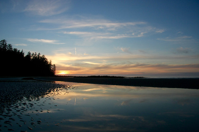
Sandra kayaking the Broken Group islands:
“Am I really going to do an 8 day kayaking trip with total strangers?” The cursor hovered hesitantly on the ‘send’ button on the Wanderung callout email I had just written. “What’s the worst that can happen?” I thought, and with one click of a finger I eradicated my indecision and sent it hurtling out into cyberspace.

Day 1: Captain’s Log Star Date: May 28. Travel from Toquart Bay to Hand Island. We are standing at the launch site in Toquart Bay. John is determined to pack what seemed like half a grocery store into his kayak and is using his entire body weight to get his rear hatch cover to close over his frying pan. Dennis, the other paddling partner is compact and has extra space which John happily fills.

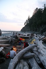
Confident that we won’t starve, we launch on a bluebird day and head for Hand Island not more than a few hours away. We land on a sandy west-facing beach and bask in the evening sun. There are purple flowers that line the entire pathway to the solar composting toilet, and if you keep going the path takes you to another secret beach on the other side. Dennis catches a rock crab and John cooks it over a fire while we marvel at being able to see the stars. We fall asleep to the sound of the tide creeping closer and the magic of these islands begins to permeate into a place in ourselves that we hadn’t accessed in a long time.

Day 2: Hand Island to Turret Island (stop to see giant tree) then paddle to Clarke Island. As he approaches shore on Clarke Island, John vaults his paddle like a javelin onto the sand and jumps out of his kayak like the snake in a can of nuts that has just been opened. I sigh and stare at my $400 Werner paddle and vow never to let John touch it. Before his boat is even pulled up and life jacket is off, John is fiddling with the bungees on his boat to free his fishing gear.

“Let’s get these crab traps out!” he yells excitedly as his paddle begins to float away with the tide.

“What have I gotten myself into?” is a thought that would linger in my mind for the better part of the afternoon and evening until I was sitting down with my first ever fresh crab presented on a plate in front of me. “Now tell us what you think of your providers now? Did the men do good or what?”

I think about this between mouthfuls of fresh crab. Even if I was barefoot and pregnant in a time when the First Nations roamed this island, I had to admit I would have still been impressed with their manly abilities to harvest what the ocean had to provide.

Day 3: Paddle around and hiking on Benson Island. I have ambitious plans of a long day of paddling around the exposed outer islands. When I tell this to the boys they stare at me with the eyes that a six year old would give you if you had just asked him to turn the Saturday morning cartoons off to go outside and play.
“But we’re tired and we want to go fishing”. We strike a compromise. Benson Island was close by, we could paddle around it and then land and do a hike to the ‘blowhole’ which was a hole in the rocks that sprayed water up like a fountain when the waves crashed into it.

This pleases them and John plops his fishing hook in the water to troll for salmon on the way over. Benson Island was originally open to camping in, but has been recently restricted to day visits only due to archeological surveying that is currently taking place. The Tseshaht First Nations in the area believe that Benson was the place where their version of the Adam and Eve story took place for their people. Anyone landing on Benson can see why. With rugged shorelines, beautiful sandy beaches and lush old growth rain forest, if life was going to start anywhere, it would make sense that it would be on this paradise island.

Did you catch anything? “No,” says John dejectedly before pulling up his line with some difficulty before realizing that he had caught a fish and just had been unwittingly dragging it around the entire paddle. His eyes light up like Christmas, “A fish! I caught a fish!” We take it to shore and John pummels it with a frying pan, a most fitting object of death for a tasty fish.

Just before we land back on Clarke we notice blows from a whale. We watch mesmerized by this underwater leviathan gently rolling to the surface to breath. Scanning the surface for krill with it’s impressive baleen, it swims further away until its blows disappear into the setting sun.

Day 4: Paddle around Wower Island to Dicebox Island around the backside of Effingham, round Gilbert and back to Clarke. Clarke Island, we were told by the fee collectors, is the best campsite in the Broken Group. We believe them immediately. There was a large sandy beach, the kind your feet loved sinking into, and directly behind was a grassy field that was consistently being mowed by fearless deer who would let you get so close you could almost touch them.

In the morning Dennis and I leave John to bask in the morning sun and we set off to explore the outer islands. As we approached the outside of Wower the waves became more hectic and confused and we bob around on the increasingly larger swell like rubber ducks in a tub filled with rambunctious children. We take shelter between Wower and Bately and watch a group of 30 sea lions on a rocky outcropping try to out-bark each other in a cacophony of sound.

We have lunch on Dicebox Island and try to image what it would have been like to land there 500 years ago and know no other life than this. In these heavily windblown, salty isolated islands life still abounds in lush green canopies and in the boundaries between the tide and far deeper than we can ever see and travel.

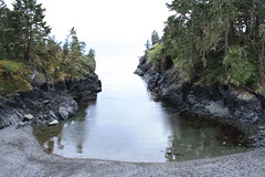
Paddling around the exposed east side of Effingham Island we can see what the ravages of wind and waves have done to the spectacular rocky shore. Sea caves and sea arches line the shoreline and we resist the urge to paddle inside as these are sacred burial sites for the Tseshaht people.

Small droplets of rain began plunking and making rings all around us with increasing intensity. The surface of the water started to resonate and shake as if there was an angry neighbour below us banging on his ceiling and yelling at us to stop making all that racket. We unwittingly obey as we silently and soggily paddled back to Clarke.

Day 5: Paddle from Clark to Gibraltar. Little islets and rocks jut up from the surface like flowers that manage to break through cement sidewalks. I try to imagine the tectonic plates underneath us causing the whole bottom of the ocean to fold and bend like peanut brittle. The pressure and friction release exploding underwater volcanoes and whole mountain ranges appear with their apexes peeking out above the surface of the water allowing us to camp on a zenith at sea level.

The site on Gibraltar is gorgeous and even though the beach is gravelly, we are glad to not be in the sand any more. The boys went fishing and I got to the task of setting up a large camp tarp when I noticed an eagle fly closer than I’ve ever seen. Dennis comes back and begins searching for a filleted fish he left on a log. After an extended search we noticed the eagle perched smugly in a tree that towered over our campsite. The mystery of the missing fish was solved: Eagle 1… Dennis 0.

Day 6: “I’ve eaten a lot of dirt on this trip,” says Dennis as he casually brushes off a piece of food that had fallen on the ground. “Well, I’d rather eat dirt than sand,” was my statement that I was about to follow up with seemingly logical reasoning. “Dirt is done and over with, sand lingers in your mouth for a while and grinds down your teeth.” “Yeah, I wouldn’t say it grinds your teeth, maybe it even polishes them, and besides…”

Dennis stops abruptly. “Wait a minute… are we seriously debating over whether we would rather eat dirt or sand?” I think that’s how you know when it’s day 6 of a trip.

Earlier that morning we paddle to the Jacques Jarvis lagoon to catch a 1 foot low tide. Diverse colours of bat stars line the bottom of the lagoon and many tiny fish dart in an out of the eel grass. John and Dennis try to catch scurrying crabs on the sandy bottom with their paddles.

We paddle into a natural fish trap and the entire channel is packed with huge red California Stickapus sea cucumbers. Measuring about a foot long, slimy and with a diameter a bit larger than an actual cucumber, these creatures have soft spikes and look like something they would make you eat on the show Fear Factor.

On the way back the sky opens up with rain and chills me to the bone. Feeling monstrously ill upon my return back to camp I fall asleep in my tent to wake up in the evening to the boys tending to a fire. “The crab curry is ready and we pre-cracked all the claws for you because we know they are your favourite.” Afterwards they cleaned up the dishes and packed away the food while I sat by the fire. I was mercifully grateful that I wasn’t alone on this trip.

Day 7: We leave the gravelly beach of Gibraltar and head to the north side of Nettle Island, cross Coaster channel, through the Pinkerton islands and back to Hand Island. I am packing up some food and tarps, Dennis is tearing down our tent and John is lying on a log in the sun wishing he was dead. That’s the funny thing about alcohol, it’s like an exhilarating roller coaster that always makes you throw up in the end. And no matter how many times it ends badly, you always line up for more.

The passages between the Pinkerton Islands take John’s mind off his unsettled stomach. They are sandy and shallow which gives the water a beautiful tropical look and we feel as though we are floating over a glowing green road to the Emerald City. If we could speak to the Wizard of Oz at that moment, I would wish for a new bladder as I had to pee, Dennis would ask for a new stomach since he was hungry, and John would probably ask for a new brain that wasn’t throbbing. We settled for lunch on a mud flat and then paddled back to Hand Island and John cast out the crab traps for the last time on our trip.

I fall asleep that evening feeling sad that tomorrow would be our last day, but exhilarated at the prospect of soon being able to shower.

Day 8: Hand Island to Toquart Bay. Hand Island gets smaller as we paddle away from it. I take a picture but it comes out looking like a small blob on my camera screen. Pictures never capture the true beauty of what you’re seeing and I try to burn it into my memory. The day is so hot the tops of my hands start to burn and when we arrive to Toquart Bay we don our wetsuits and take our kayaks for a swim and do some rescue practice.

Finally after packing up our boats we walk smelly and salt incrusted into a pub in Port Alberni and watch the Canucks win game 2 of the final series. After a well earned beer, a lingering goodbye we part ways so I can start writing this rather lengthy trip report and prepare for our next trip.

West Coast Trail 05/06/10

Su-Laine on the West Coast Trail:
“Yeah, we made it! Six days on the West Coast Trail went by quickly for our group, with one regret being that we didn’t make it a longer trip and visit the beaches of the south end. The southern 13 km of forest trail have no redeeming qualities whatsoever, and the next 9 km feel almost as pointless except for the satisfaction of having several dozen ladders and countless bottomless mud pits behind you. Despite improvements over the decades, this is still a tough trail. Good things to have are sturdy well-broken-in boots, tall gaiters, bicycle gloves, two poles each, and microspikes for slippery logs. You need balance and agility to get anywhere. After two long days trudging through the south end, the lovely beaches and faster hiking conditions of the north end were a joy. It’s a beautiful trail for gazing into tidepools, for swimming in creeks and waterfalls, and for exploring seaside rock formations.

As we’d hoped, the trail was comfortably uncrowded, and finding good camping spots and room in the metal bear boxes was no problem. The mice are definitely back, especially at Tsusiat Falls – don’t delay in getting your food to into the bear boxes in the evenings! One other thing to know is that Telus cell phones work on the trail but Fido ones apparently don’t.

We got to know our fellow south-to-north hikers a bit, enjoying their company at shared campfires and at a brilliant brunch at Tides and Trails restaurant on day six. Hiking times were very long on most days and there wasn’t much free time, but we took a break for burgers at Chez Monique and spent some unhurried time at the beach, and entertained ourselves by building a bridge across the Darling River. We managed to see some whale spouts but not much else in terms of rare wildlife. There was a sense that there is more to the trail than we could see that week, giving all three of us some desire to go back.

P.S. The Parks Canada staff said July and August are fully booked and that there are still some reservable dates in June. September is reportedly an excellent and uncrowded time to do the trail.”

Ladder

Wild Side Trail 22/05/10

Paige on the Wild Side Trail:
“Ten of us hiked the Wild Side Trail, which is a little known hike across Flores Island. It requires a water taxi ride from Tofino to Ahousaht, which is a First Nations town on Flores. The hike to Cow Bay is only 10 km through the forest with a good amount of beach walking for the tired or lazy. Not many people know about the hike, and you’re almost guaranteed to see bald eagles, otters, seals, sea lions and possibly bears or wolves.

It’s definitely worth making the trek out that way – the sunset at Cow Bay is gorgeous (see Chris M’s photo in the Wanderung Flickr Group) and we watched whales only a few feet from us while we collected mussels to eat at the campfire. It’s also possible to kayak there from Tofino.”

Cow Bay

Juan de Fuca Trail 21/05/10

Stephen P. on the Juan de Fuca Trail:
“Don’t Juan de Leave, the Juan de Fuca Trail – 2010 May Long Weekend…

Backpacks filled. Cars gassed. Ferries reserved. Off we go. Forty-seven km muddy trudging, suspension bridges, waterfalls, although more beach hiking would be nice. Chilly nights, many water sources, abundant gorgeous pictures, and cool ocean winds to cool you off while hiking. Trail descriptions claim 25 m elevation gain, this occurs over, and over, and over, again. I found this much easier on my beat up knees than the usual alpine hike, as the multiple descents were very short.

We avoided car accessible campsites to stay away from tent city high schoolers, our daily hike distances varied accordingly: 2, 19, 12 and 14 km.

Great campfires, unfortunate broken promises of sunrise yoga, laughter that echoed across the cool waters of Juan de Fuca Strait, on the fly doggie bag MacGyvered gaiters. Thanks to J, D, R, M, I-S, V, and S for making a memorable trip.”

West Coast Trail 09/06/09

Heather on the West Coast Trail:
“Ribeka K, John A, Bob M, and Heather W did a glorious 9 day backpacking trip along the classic West Coast Trail of Vancouver Island from June 9-17. No wonder this hike is rated as #1 in the world – it is as stunningly gorgeous and amazing as everyone says. Our adventure included hiking pebble beaches, wandering around sandstone benches & cliffs, climbing up and down ladders on slopes in the forest, slipping along muddy trails and broken boardwalks, ambling on sandy beaches, negotiating cable cars, swinging on suspension bridges, and passing lighthouses, caves, arches, and rocky headlands. We marvelled at the many waterfalls, tide pools, whale sightings (four days!), sea stacks, sea otters, martins, bald eagles, sea lions, windswept trees and wildflowers. The trip included great campfires every night, heavy packs, jumping into amazing swimming holes, fantastic company, stupid amounts of food, and intense debates over jelly bean flavours. We were very lucky to have no rain for 8 days, and the fact that it hadn’t rained for almost a month resulted in mud only being up to our ankles instead of over our knees! Other highlights included the milkshakes & burgers in Bamfield, having the local water taxi drop us on a deserted beach for our last night camping, and AMAZING whale watching on the boat that took us back along our whole hiking route to Port Renfrew. If you go, do it before June 15 or after Sept 15, and don’t forget the marshmallows!”

10244

East Sooke Trail 03/05/09

Erez on the East Sooke Trail:
“On a cloudy Sunday, Phil, Iris and I took the Ferry to Vancouver Island, drove past Victoria to East Sooke to the Aylard Farm trailhead of the East Sooke coast trail. The entire trail is about 11 km, but since we had only one car we hiked only to Cabin Point, taking the interior trail back to Aylard Farm. It took us about 1.5 hours to reach Beech head (a bluff overlooking the ocean), and another 1.5 hours or so to get to Cabin Point. The interior trail from there back to Aylard Farm turned out to be rather short and after an hour we were back in the car. Although it does not have any serious elevation gain the trail is not level and goes up and down quite often. The scenery was great – thin forest, green meadows, lots of Arbutus trees, emerald-coloured ocean, little coves, all made the trail quite interesting to walk on. We saw a woodpecker, a couple of eagles, and interrupted a sleeping seal at Cabin Point. There were very few people hiking the trail with us. Our only regret was not to have two cars so we could have hiked the entire trail. Oh well, next time.”

reduced_img_1025