Tag Archives: Mt Gardner

Mt Gardner, 26 Mar 2015

Bob H. on Mt Gardner:
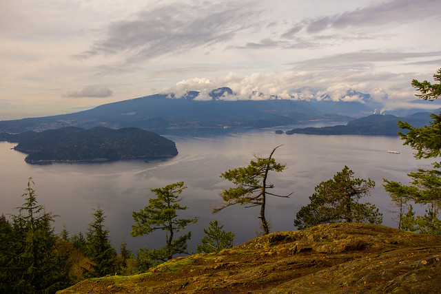
“I had to go to Bowen Island today, so I said, why not do a hike too! It was 14 degrees C and cloudy at the start. Deep in the forest it got down to around 10, but that’s it. It was very comfortable all day. Some mosquitoes were bothering me, but no bites – so that’s good! I had the fortune of having the car today, so we started right at the trail head (126 m). If you hike from the ferry, there is an extra 3 km and 175 m elevation gain. From the trail head, we started up the gravel road and then veered slightly left into the forest. We re-emerged onto the gravel road 1.3 km later and continued up the road for another 1.3 km. We entered the forest again and continued our climb to the summit. The trail is very peaceful, with the sounds of birds and small streams. Just before the approach to the summit, there are ropes for assistance, as it’s a pretty steep section – they help, especially going down. When we got to the top (715 m), we stopped for a break on one of the two helicopter landing pads up there. Unfortunately, there was zero visibility at the summit, so no good photos from the top! There are a number of telecommunications antennae and repeaters up there. We saw only two other people today. The round trip distance was 8 km and the total elevation gain was 690 m.”

Great view from here (550 m)

Mt Gardner 21/05/11

Carollyne on Mt Gardner:
“Even with the very low overcast clouds and showers, this trip was excellent. One goal was not to get lost, unlike every other time I’ve done this hike, and we didn’t, even though the route wasn’t totally as planned. Thanks go to VOC Wiki’s excellent map, Vancouver Trails info and the much improved signage. We intended to take “The Handlogger’s Trail” (Mat Hill trail in 103 hikes) to N. Mt. Gardner trail. Shortly after we began we found a crevasse of a washout. Although the stream flow was low and it would have been easy to cross, this route no longer looked promising so we double backed and took the road until N. Mt. Gardner Trail. From there it was straight forward to the ropes and the helipads, with 360 degree white wall views of cloud. Following a short lunch break, we returned making a loop via the trail near the opposite helipad, the S. Mt. Gardner trail. Total time: 5 h 15 min Cove to Cove. We finished off with dinner at Doc Morgan’s and were back in Vancouver by 6 pm. Other than the washout, the trail was in excellent condition and not muddy. I also picked up a good free map, “Bowen Map & Guide 2011″ on the ferry that seems to include all the trails on Bowen.”

Mt Gardner 26/04/09

Heather on Mt Gardner:
“Nine of us ventured over to Bowen Island climb Mt. Gardner on a gloriously sunny, clear day. We picked a slightly longer route – taking the trails through Crippen Regional Park from the ferry to the trailhead. We did a circular route, on the way up we branched off the main trail to circle around the east & north side of Mt. Gardner, then came back down past the south summit back to the main trail. There are some nice views to the North from a few bluffs, and then a steep section to climb up to the North Summit. We passed a few tiny patches of snow, but almost all trails are now clear. All trails on this hike tend to be confusing, but the group managed to follow this route by combining people’s experience from previous hikes, a trail description from 103 Hikes, and a little back-tracking! The views from the top were beautiful, even though you have to circle around a bunch of radio towers and other structures – and the helicopter landing pads are great for stretching out and soaking up the sun! It was definitely busy up there – probably 40 hikers enjoying this classic early season hike. As always, this hike was also fun for the great company – from a number of first-time Wanderungers, to our ultra-marathon runner just back from Antarctica, we always had some interesting conversation going on!”

Mt Gardner 18/04/09

Paul T. on Mt Gardner:
“There is still over a foot of snow at the North Summit of Mount Gardner (the summit with the microwave towers and the view). The group took the north approach to this summit, the Skid Trail, which has some patchy snow still but none of us felt the need to strap on extra traction in the way of Yaktraks or crampons to deal with it. There is a lot of blow-down between the South and North summits and spotting the trail markers can be tricky. Signage also is confusing. While there are a couple of new, large wooden signs for the South Summit (the highest point on the island but viewless because forested), the only sign indicating the North Summit is small, and the handwritten label so faded that it’s almost illegible. We returned by trail that leads from the North Summit down the south side of the mountain. There is more snow on this side, and the going a bit tricky, but extra traction is not required. Lots of blow-down here as well and easy to lose the trail. We took over an hour out for breaks and the round trip (ferry terminal and back) ended up taking 6 1/2 hours.”

Mt Gardner 22/03/08

Hurrian P. on Mt Gardner:
“With a little help from an SFU/UBC hiking group named, not-so-creatively, “Hiking Group”, the five of us were able to find the trail head to Mount Gardner. The path was quite tricky to find at times and there were crossroads without clear markings. Only the top few hundred metres was snow-covered but it was quite slippery on the north slope, especially the final steep section. On the way back, we decided to take the alternative route and followed a very sparse trail back to Snug Cove – often the only way that we could tell that there was a trail were the signs that some very adventurous soul had decided to mountain bike that route down from Mount Gardner. Our conversations, although diverse, intellectual and entertaining always found their way back to Wikipedia sex scandals – ask Su-Laine.”